by Julie Dodd
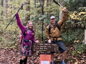
The Tour de Smokies is underway for Nancy East and Chris Ford.
The two experienced hikers set out on Sept. 4, with the goal of hiking all 900 miles of trails in the park to raise $60,000 to help fund Great Smoky Mountains National Park’s Preventive Search and Rescue (PSAR) program.
Each year GSMNP is involved in more than 100 search and rescues (SAR). Many of those rescue efforts could be avoided if park visitors made good decisions about which hikes to take and were better prepared for their hikes.
The funds Nancy and Chris raise will fund two rangers who will train volunteers to talk with park visitors before they get on the trail to make good hiking decisions. The rangers also will plan and assist with search and rescue operations.
The catalyst for Nancy and Chris’ Tour de Smokies is to promote hiking safety in GSMNP. Nancy is a volunteer for the Haywood County (North Carolina) Search and Rescue Team and has been involved in a number of rescue efforts.
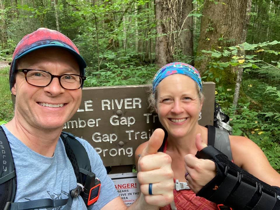
Between the two of them, Nancy and Chris hiked 7,500 miles in the last 18 months as they prepared for the Tour de Smokies. The photo at the top of this post was taken in Elkmont when they completed their last long training hike before starting the Tour.
While they are hiking their Tour de Smokies, FOTS will publish a series of posts of advice from Nancy (trail name “Seal Mom”) and Chris (trail name “Pacer”) to make hiking safer for all hikers. You can follow the team’s daily hiking progress on Nancy’s Facebook page.
For this post, Nancy discusses the planning involved in hiking safely and recommends hiking navigation tools.
Create a hiking plan
FOTS: You have said it’s important to have a plan for the hike. Why is a hiking plan important and what does that planning include?
Nancy East: A hiking plan is important for a couple of reasons. First, it’s helpful in discerning whether or not the hike is safe, given its conditions, and if it’s within a hiker’s physical abilities.
Things to consider when planning a hike are the following:
Mileage of the route
The mileage of the route. Keep in mind that mileage doesn’t always align with exertion though. For instance, Chimney Tops Trail is incredibly steep and challenging for its 2.0 mile distance. There are park trails that are twice as long that won’t leave you heart, lungs and knees screaming nearly as much!
Elevation gain and loss
The elevation gain and loss of the trail should also be considered, in conjunction with the mileage. The Gaia GPS is an excellent tool for determining elevation gain and loss.
Another excellent resource to glean this information is Hiking Trails of the Smokies (a.k.a. “The Little Brown Book”).
Season of the year
Consider the season you want to hike a route and if it’s within your capabilities.
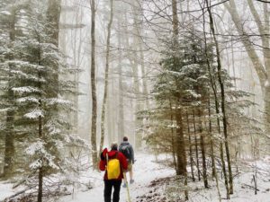
For example, higher elevations in the Smokies are often covered with snow during the winter. Without winter-specific gear, like microspikes (ice cleats), it’s best to avoid areas like this.
In the summer, many trails in the interior of the park are overgrown, increasing the risk for slips and falls. None of these are show-stopping challenges, but it’s important to consider if you’re not prepared for the conditions. If in doubt, call the Backcountry Information Office (865-436-1297) and get their input.
Trail obstacles
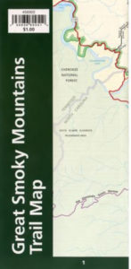 Consider potential obstacles inherent to a specific trail, such as hazardous water crossings. The “$1 Map,” available at any GSMNP visitor center (or for purchase online), has a list of trails and potentially dangerous crossings after heavy rains. Heed those warnings, and call the backcountry office, if in doubt, to get their input on the potential danger.
Food and water
Food and water needs should also be determined while making a hiking plan. There’s nothing worse than drinking your last drop of water, only to discover you won’t come across another water source for several more miles!
I also encourage hikers to carry a little more food than they think they’ll need on a hike, just in case they’re out longer than they expect. (More on this in an upcoming blog post.)
FOTS: Why is it important to let someone know your hiking plan?
Nancy East: It’s incredibly important to leave your hiking plan with a friend or family member and to let them know when you emerge from the woods safely. If something happens and you’re in need of help, the person who knows your plan should contact the park service if you don’t contact them by a predetermined time you agree upon before leaving. A hiking plan gives search and rescue teams a starting point if a hiker doesn’t return from a hike.
Navigation tools for hiking
FOTS: Why do hikers need to carry a park map, a compass and even a satellite device? Aren’t the trail signs and a cellphone adequate?
Nancy East: Navigation intimidates most novice hikers, but it doesn’t need to be overly complicated. Navigational apps, such as Gaia GPS, provide a real-time snapshot of where hikers are on a trail, even without cell reception.
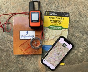
There’s absolutely nothing wrong with using a navigational app, and I even encourage every hiker to take the time to learn how to use one. However, it shouldn’t be the only thing hikers learn and carry.
All it takes is an unexpected dead battery or a phone dropping in a creek (I speak from experience!) to eliminate your only form of navigation.
Side Note: Through my blog, I am able to offer hikers up to 50% off Gaia GPS. I can’t say enough good things about this app, and I use it on every single hike I take. The discount can be accessed through this link.
A topographic map, paired with a compass, should also be in every hiker’s backpack. Even the “$1 map” is better than carrying nothing.
Learn to use your navigation tools before hiking
And remember that a compass is just extra weight in your pack if you don’t know how to use it. Take the time to learn the basics of reading a topographical map and using a compass. Many outfitters will offer classes, but I personally learned most of these skills by purchasing a navigation book and practicing in the field.
Tech Tip: Always put your phone in airplane mode when you leave for a hike to preserve the battery life. And in winter, keep it as warm as possible. (I like to activate a chemical hand warmer and keep it in the same pocket as my phone if it’s really cold.)
Finally, one of the best navigational tools a hiker can use doesn’t weigh a thing. It’s a method called “dead reckoning.”
In my opinion, it’s just as important to learn dead reckoning as it is to carry a map and compass. (You can read about dead reckoning and other navigation tools on my blog.) In short, it amounts to keeping track of the time it takes you to hike between certain landmarks, such as trailheads. I use dead reckoning on every single hike I take, and it can actually turn into a fun “game” as you get better at it with experience.
Limited cellphone reception in GSMNP
FOTS: I’ve heard quite a few hikers say, “If I have any problem, I can use my cellphone to get help.” As you’re experienced in search and rescue, what would you say to them?
Nancy East: As someone who has hiked all of the park’s trails twice, I can attest to the fact that cell reception is very limited in the park. It’s never ever a good idea to rely on it, especially if you have an emergency situation and need help.
One of the most harrowing experiences I’ve ever had as a hiker is when I came across two teenage boys in the Deep Creek trail network who had become separated from their group and were lost. It was winter, raining and the temperature was in the 40’s, perfect conditions for hypothermia, especially since they weren’t dressed appropriately.
When I came across them, they were very tired, soaked and very cold. This was troubling enough, but what bothered me the most is when one of them told me they were considering heading off trail to try and get higher up on the mountain for cell reception.
If they hadn’t come across me when they did, I fear the worst may have unfolded. I felt compelled to write a blog post about the experience, as there were many lessons learned from their experience.
Personally, I wish every hiker could carry a personal locator beacon or satellite device with an SOS feature. Chris and I both carry the Garmin InReach Mini. It allows us to send a signal with our GPS coordinates to emergency services if we have an injury and can’t hike out or if we become lost.
But it also allows us to send personalized messages to convey why we need help. It can also be used to send messages to our spouses, if we’re running late getting off trail, want to tell them we’re safely in a backcountry camp for the night, etc.
Stay on the trails
FOTS: Hikers who have a map may think a shortcut they would devise could be faster or more adventurous than following the trail. Why isn’t that a good idea?
Nancy East: Unless someone is highly proficient with map and compass navigation, I would strongly discourage off-trail travel. If you veer from your planned route and get injured or lost, you instantly become the proverbial “needle in a haystack” to SAR teams. Also, the terrain of the Smokies is brutal and unforgiving in many places, so your risk of injury increases significantly off trail.
Even experienced hikers have accidents
Nancy and Chris had a reminder of how even experienced hikers with the right gear can have accidents.
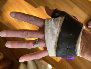
In early August, Nancy fell during one of their training hikes. She said the fall was a “fluke.” She and Chris were hiking on a section of the Appalachian Trail that wasn’t tricky terrain.
She slipped on wet grass and mud and fell on her left hand. She said her trekking poles probably kept her from falling even harder than she did. The fall caused a ligament in her thumb to tear away from the bone.
When Nancy had an appointment with her hand surgeon and told him about the fundraiser for GSMNP, he scheduled her surgery for the next day so she could have as much recovery time as possible before starting the Tour de Smokies. Nancy is wearing a hand splint while she hikes.
Support Nancy and Chris’ Tour de Smokies
You can support Nancy and Chris’ hiking journey and improve safety in GSMNP for all hikers by making a donation on FOTS website or on the Facebook fundraiser page.
Your donation can help Nancy and Chris make progress toward their goal of raising $60,000 for GSMNP Preventive Search and Rescue program.
We hope you’ll virtually follow Nancy “Seal Mom” East and Chris “Pacer” Ford during their Tour de Smokies fundraiser hiking journey.
Regular updates and photos from their daily hikes will be provided through Friends of the Smokies and Nancy’s blog, Hope and Feather Travels, and social media channels.
When you hike, be sure to carry The Ten Essentials recommended by the National Park Service.
Tour de Smokies Sponsored by
![]()